FREE Printable: Megamaps
Published:
September 29, 2015

Contributor:
Carrie
Disclosure: This post may contain affiliate links, meaning if you decide to make a purchase via my links, I may earn a commission at no additional cost to you. See my disclosure for more info.
Here’s a great resource for your history or geography curriculum! Print out free maps in a variety of sizes, from a single sheet of paper to a map almost 7 feet across, using an ordinary printer. You can print single page maps, or maps 2 pages by 2 pages, 3 pages by 3 pages, etc. up to 8 pages by 8 pages (64 sheets of paper; over six feet across!)
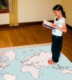
Click here to download your free printable!
Carrie
Carrie Fernandez is the owner of Daily Skill Building. She has been homeschooling for over 18 years, has two girls and works side by side at home with her awesome husband. She has been saved by grace, fails daily, but continues to strive toward the prize of the high calling of being a daughter of the Most High God.